This page was designed to illustrate a way to plot a field boundary, compute field perimeter and area based on recorded GPS output. Plotting a field boundary is one of initial practices of site-specific field management. The data is collected from a GPS receiver while walking or driving along the perimeter of a field. Geographical coordinates of boundary points can be used to determine shape, perimeter and area of the field.
At first, a data set shall be imported (if a spreadsheet application is used) and filtered. Points with invalid GPS output (no differential correction) should be excluded from the data. It is important to pay attention to the points of entrance and exit from the boundary. Position in decimal degrees with corresponding sign should be computed for each point. Then, easting and northing in local coordinates should be found for each point. If there is no specific need for a remote origin of local coordinates, the south-west corner of the field may be assigned zero easting and northing. An average latitude and known field elevation may be used to define Flon and Flat conversion factors .
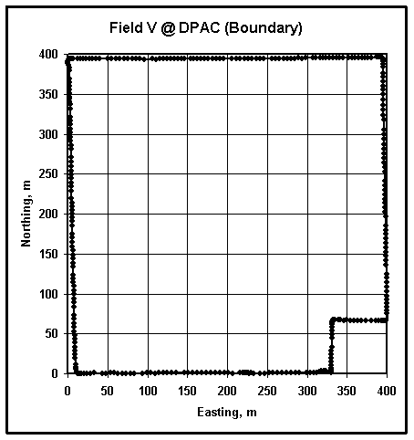
Converted data may be plotted in x-y coordinates (x - easting, y - northing), as shown in the figure above. The scale of both axes must be the same. By stretching the graph, a square grid can be achieved. This plot shows the shape of the field boundary.
Since the data set represents a series of sequential points, the sum of the distances between each pair represents the field perimeter. The following formula could be applied (n - number of discrete boundary points):
Area of the field may also be approximated using discrete boundary points. Several approaches may be taken to define the closed loop integral of the function y = f(x). Most of them will simplify to the following formula:
When determining the perimeter and area, pay special attention to the first and the last value. Using a spreadsheet, copy coordinates of the first point to the end of the data set or adjust formulas in the last row to use the first point instead of nonexisitng i+1.
You may exercise plotting field boundary using following files:
web_boundary_3.csv
- Comma delimited GPS output (portion of "$GPRMC" sentences) from Field
3 at Agronomy Research Center (West Lafayette, IN).
web_boundary_data.xls - Extracted longitude and latitude in decimal degrees
from boundaries of Fields V and R at Davis-Purdue Agricultural Center (Farmland,
IN).
Verify your results using
web_boundary.xls.