
This page was designed to illustrate a way to convert GPS receiver output into linear units for georeferenced data analysis.
The most common ASCII output of any GPS receiver is a set of comma delimited lines (sentences) defined by National Marine Electronic Association interface standard NMEA-0183. Every line follows the same pattern, as shown in the following example:
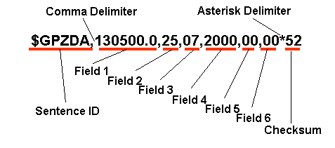
Information expressed by each field depends on the sentence, some of which are identified as:
In order to extract information related to the position of a GPS antenna, it is necessary to record at least one of four sentences: $GPGGA, GPGLL, $GPRMC, or $PTNL,GGK. Each of these four sentences indicates geographical longitude and latitude of position fix and corresponding UTC time (Universal Time Coordinated). As it will be discussed later, the height above ellipsoid is also required in order to accurately process GPS data. However, only $GPGGA, and $PTNL,GGK sentences contain information related to the altitude of a GPS antenna. If only $GPGLL or $GPRMC sentences are recorded, the height above ellipsoid should be known or assumed.
Both the latitude and longitude values included in an NMEA-0183 sentence are presented in degrees, minutes, and decimal minutes. Latitude is presented as ddmm.mmmm, while longitude is presented as dddmm.mmmm in a single field. The direction of latitude and longitude are indicated as a single character in the next field ('N' - north; 'S' - south; 'E' - east; 'W' - west). Most computations that involve geographical coordinates require longitude and latitude to be expressed in decimal degrees with a corresponding sign (negative for south latitude and west longitude) (as shown in the figure below). The conversion of latitude or longitude into decimal degrees is usually done as:
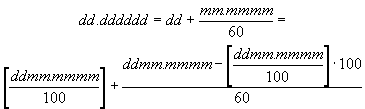
Note: Square brackets mean integer of a value inside (can be used in a spreadsheet application).
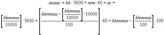
A UTC time that corresponds to the position fix can be used to measure change in geographic location over time (travel speed). It is expressed in hours (00 - 23), minutes (00 - 59) and seconds (00 - 59) (decimal fraction of a second may also appear). Data computation requires time values to be continuous. This is usually done by calculation of seconds from the beginning of a day (UTC reference) in the following way:
The height over ellipsoid (h) can be directly obtained from an NMEA-0183 sentence ($PTNL,GGK) or computed as a sum of antenna height with respect to MSL (mean sea level) reference, and the geoidal separation extracted from an NMEA-0183 sentence ($GPGAA).
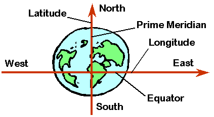
Geographical longitude and latitude represent angular measures of a position on the Earth's surface. A longitude ( l) defines west-east position with respect to the prime (Greenwich) meridian (000 - 180), while a latitude ( j) indicates north-south position with respect to the equator (00 - 90). Several models have been developed in the past to represent our planet. For GPS technology, WGS-84 (World Geodetic System 1984) has been adopted. This model assumes an ellipsoid with a semi-major axis (equatorial radius) a = 6,378,137 m, and a semi-minor axis (polar radius) b = 6,356,752.3142 m (defined as f = 1/298.257223563, where f = (a-b)/a).
While practicing site-specific field management, it is necessary to interpret change of geographical coordinates in terms of distance. Conversion of longitude and latitude into linear units is not trivial. Since all meridians intersect at two points (poles), the distance corresponding to a particular change of longitude depends on the latitude. On the other hand, the fact that the Earth is represented by an ellipsoid (not a sphere) model suggests that a change in latitude may also correspond to different distances depending on the north-south position. In addition, the height of a field over the ellipsoid affects both longitude and latitude conversion factors.
Usually, an agricultural field has relatively small size (with respect to the Earth), and may be considered as a flat surface at a particular location on the Earth. Therefore, in order to convert geographic coordinates into linear units it is necessary to define the distance corresponding to a 1º change in longitude (Flon) and latitude (Flat) for a specific field location (average geographic latitude j and height over ellipsoid h). These conversion factors could be computed using a set of derived equations or obtained from a table.
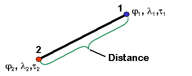
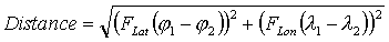
After recorded data have been converted into decimal degrees with corresponding sign, and appropriate conversion factors have been established, analysis of georeferenced data may be conducted. Primary tasks of GPS data analysis include determination of the distance, travel speed and heading based on coordinates of two points. Distance calculation can also be used to establish a local system of coordinates with easting and northing axes scaled in linear units.
Distance between two points (figure below) can be found using the following formula:
Time between two recorded points is found as the difference between corresponding UTC values (t2 - t1). Distance divided by time gives travel speed.
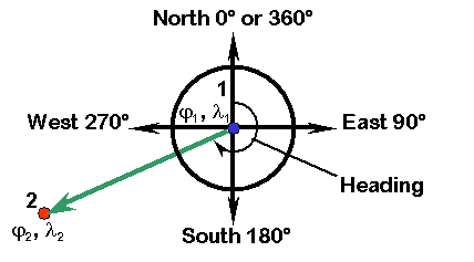
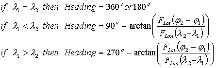
Travel direction (heading) is also needed in many applications. It can be found as shown in the figure below using the following formula:
This exercise is based on real data collected using Trimble AgGPS 132 receiver.