Tutorial on Application of ArcGIS Software for Precision Agriculture
McGill Universiity
Department of Bioresource Engineering
Introduction
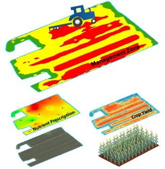
Implementation of Precision Agriculture involves the use of geospatial information to improve the understanding of the spatial heterogeneity of soil properties and crop performance. Accounting for local needs allows for optimizing the use of agricultural inputs to maximize profitability and to reduce the negative environmental impact. Geographic Information Systems (GIS) have been used to manage, process, and interpret multiple geospatial data layers. This tutorial was developed to provide step-by-step instructions on the way in which a popular, generic GIS software package could be used to process geospatial data for an agricultural field in Quebec. This tutorial was developed based on ESRI ArcGIS 10.5 Desktop (ArcInfo version). This software is popular within academic and government institutions around the world. Although this software is not specifically customized for agricultural data management, its powerful functionalities offer practical toolsets to meet the key requirements. All of the lessons are developed using a variety of input data files (i.e., spreadsheets, delimited text files, shape files, images, etc.) for an actual farm site located near Saint-ThÚodore-d'Acton (Quebec, Canada). Please e-mail viacheslav.adamchuk@mcgill.ca to obtain the username and password to access the data. It is assumed that the users of this tutorial are familiar with the basic functionalities within an ArcGIS environment. Nevertheless, the level of challenge to complete the designed tasks is moderate due to short descriptions and clear screenshots.
This tutorial consists of four separate lessons: 1) data management, 2) data interpolation, 3) spatial analysis, and 4) satellite imagery processing. The goal for the first lesson is to introduce the operational environment and conduct basic data management tasks, including clipping, projection, georeferencing and digitizing. The second lesson is designed to introduce the most essential step in precision agriculture data processing û data interpolation. The most extensive third lesson introduces different methods to develop application prescription maps for the main agricultural inputs, such as fertilizers and lime. Finally, the fourth section covers the use of satellite imagery to generate prescription maps. Each lesson is independent of the previous one and can be completed in any order.
Disclaimer:
Commercial products mentioned in this tutorial are for demonstration only and do not imply endorsement by the authors or the McGill University or the exclusion of other similar products.
Lessons
Lesson 1 - importing and preprocessing field data from
Dataset1.zip
Lesson 2 - data interpolation using Dataset2.zip (result of lesson 1)
- Exercise_Site20_2-1 - Interpolating soil sampling data (Geostatistical Analyst - Ordinary Kriging)
- Exercise_Site20_2-2 - Interpolating crop yield data (Geostatistical Analyst - Inverse Distance Weighting)
- Exercise_Site20_2-3 - Creating a systematic soil sampling grid (ArcToolbox - Data Management Tools - Feature Class - Create Fishnet)
- Exercise_Site20_2-4 - Extracting values based on points (ArcToolbox - Spatial Analyst - Extraction - Extract Multi Values to Points)
- Exercise_Site20_2-5 - Summarizing points data within polygons (Spatial Join)
Lesson 3 - spatial data analysis using Dataset3.zip (result of lesson 2)
- Exercise_Site20_3-1 - Developing a P fertilizer prescription map (ArcToolbox - Spatial Analyst û Map Algebra - Raster Calculator & ArcToolbox û Spatial Analyst û Reclass û Reclassify & ArcTookbox û Conversion Tools û From Raster û Raster to Polygon
)
- Exercise_Site20_3-2 - Developing a K fertilizer prescription map (ArcToolbox - Spatial Analyst û Reclass - Reclassify & ArcTookbox û Conversion Tools û From Raster û Raster to Polygon
)
- Exercise_Site20_3-3 - Developing a lime prescription map (Geostatistical Analyst - Ordinary Kriging & Attribute Table - Join)
- Exercise_Site20_3-4 - Developing a yield goal and N fertilizer prescription map (ArcToolbox û Spatial Analyst û Map Algebra û Raster Calculator & ArcToolbox û Spatial Analyst û Neighborhood û Focal Statistics)
- Exercise_Site20_3-5 - Development of yield productivity management zones (ArcToolbox û Spatial Analyst û Map Algebra û Raster Calculator & ArcToolbox û Spatial Analyst û Neighborhood û Focal Statistics)
Lesson 4 - satellite imagery processing using Dataset5.zip
- Exercise_Site20_4-1 - Multispectral images (Landsat 8 OLI)
- Exercise_Site20_4-2 - NDVI calculation (ArcToolbox û Spatial Analyst û Map Algebra û Raster Calculator)
- Exercise_Site20_4-3 - Nitrogen application based on NDVI (ArcToolbox > Spatial Analyst Tools > Map Algebra > Raster Calculator)
- Exercise_Site20_4-4 - Digital number to reflectance conversion (ArcToolbox û Spatial Analyst û Map Algebra û Raster Calculator & ArcToolbox - Spatial Analyst û Reclass - Reclassify)
The result of lesson 3 is available in Dataset4.zip.
The result of lesson 4 (exercises 1-3) is available in Dataset6.zip.
The result of lesson 4 (exercise 4) is available in Dataset7.zip.
Contact Information
Viacheslav I. Adamchuk
Associate Professor, Department of Bioresource Engineering
Phone: (514) 398-7657, E-mail: viacheslav.adamchuk@mcgill.ca
Return to the home page